THE FIRST DAY OF THE LÖTSCHENPASS HIKE

PHOTOS BY MARK, JON G, DAVE, JON W, SARAH, ANGE & OTHERS

scoutlogo
explogo
netlogo

logo
blank
 
 
Expedition Map
 
Profile
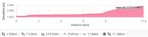
1,726m Total Ascent to a highest point of 2691m
11.4Km distance.
 

THE BANK MANAGER AND CLERK

 Day 9 

This is the big one. Two days of walking including a sleep over in a hut perched in a high alpine pass on the edge of a Glacier.  This would be our first contact with ice! This is the hike all the others have simply been a warm up for.  This time we would be going into remote and desolate locations.   But first the Scouts had to withdraw pocket money from the camp bank run by Jon and Chez.


Once again we hiked in four small groups.  After a week we had worked out who walked at what pace and the groups were very much created with that in mind.

 Girls from the Network and one of the girls from the Scouts set off first with Mark.  They were followed shortly by most of the Scouts led by Jon and Chez.  Next came the younger explorers and the fastest Scout along with Geoff and finally the fit group who spent most of the morning ferrying the slower walkers up the remote Gasternal Valley. 

THE GIRLS ON THE BRIDGE
Explorers

THE EXPLORERS ON THE  BRIDGE

WOBBLY BRIDGE OVER THE KANDER

CLIMBING UP THROUGH TREES

 We started from the village of Selden some 15 minutes drive along a dirt track and cliff edge roads that passed through tunnels hewn from solid rock.  From the village we crossed the raging river Kander on a wobbly bridge before starting the first stage of our climb.  This path would take us to the top of the tree line.  Due to the heat we were glad to be in the shade of the forest although we did pop out into the sun occasionally to catch the spray from the impressive waterfalls.  At the top of the forest was a hut that each group paused at to get Hutten test cards stamped and to obtain ice creams.

 
Trees
THE FINAL LEADER GROUP HAVE TO WAIT FOR
THE SCOUTS AND EXPLORERS TO MOVE AHEAD
 
ICE CREAM AT THE BERGHAUS GFELALP

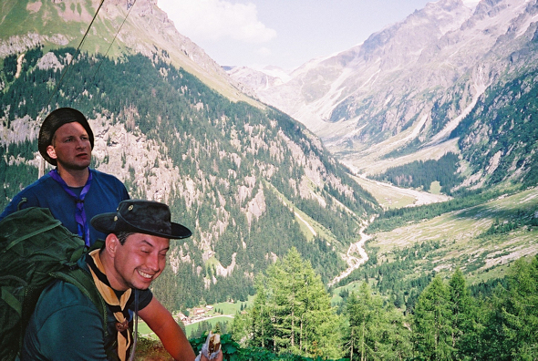
At this point, we invite you to fast forward twenty years to the Romford District Explorers Summer Camp at Kandersteg International Scout Centre. On that occasion the Berghaus Gfelalp was the destination for the Overnight Hike. Back in 2003 and on every 3rd Gidea Park visit to Kandersteg, the Berghaus Gfelalp hutt is somewhere you pass late morning. It's about 150m below our usual lunch stop. In 2003 we stopped for an Ice Cream.
Kids today!
 

SCOUTS

WALKING ABOVE THE TREE LINE

 
SCOUTS

LUNCH STOP

MARK ATTEMPTS TO RE SOLIDIFY HIS SNICKERS

From the Bergus hut we continued to climb but now without shade.  As we climbed the Kanderfirn glacier slowly revealed itself at the head of the main valley.  Eventually our route opened out into a flat alpine pasture from where we could see our glacier high above us.  This is was felt was a suitable place for the Scouts to break for lunch.
Lisa
 

COOLING OFF AFTER LUNCH
THE KANDERFIRN GLACIER CAN BE SEEN IN THE DISTANCE

SCOUTS

ON AND ON

After lunch the path continued to climb.  As we got closer to the Lötschenpass Glacier the path got rockier. The high altitude may the walking slightly cooler but it was still thirsty work.

By now the first Explorer Group had overtaken both Scout groups but the fastest Explorers were still behind and waiting.

THE LAST GROUP REST

MARK AND THE GIRLS

Before stepping onto the ice the Scouts and Explorers were briefed on the environment of the Glacier and the dangers in crossing one.  We rested on the remains of a lateral moraine at the fringe of the Glacier.

THE EDGE OF THE ICE

 
<- IN CAMP

SUMMER CAMP HOME

THE GLACIER -->